 Réserver ses vacances
 Ferienvermietung
 Séjours en résidence
 Sonderangebote
 Réserver hôtel
 Aufenthalte
 Eskapaden
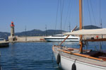 Segeln
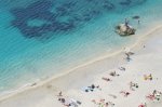 Strände und Küste
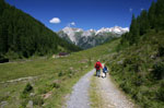 Rando
Rando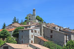 Tourismus
 Entdeckungen
 Kinos
Kinos Filme
Filme Restaurants
 Rezepte
 Aktivitäten
 Ausgehen
 Autovermietung
 Fähre Korsika
 Bons plans Côte d'Azur
 Monde portée de Nice
 Flugtickets
 Immobilien
 Kleinanzeigen
 Facebook
 Photo de la semaine
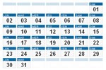 Agenda der Woche
 Tageskalender
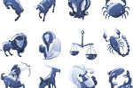 Horoskop
 Events
 Geheimtipps
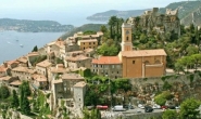

Randonnées
Col de Gialorgues - Haute Tinée 1 - Haut Pays
IGN-Karte : "Haute Tinée 1"
Top 25 n°3639 OT
1:25000e
Informationen
- Geografischer Bereich : Haute Tinée 1
- Zeitraum : juin à octobre
- Schwierigkeit : rando moyenne
- Dauer : 4h AR
- Anstieg : + 600 m
- Abstieg : - 600 m
«Wanderung Circuit du Bois d'Anelle retour Wanderung Crête de la Blanche»

Contact rando : rando@cote.azur.fr